Map of Expo 2010 Shanghai |
|
 |
|
Tools for Expo Visitors
MAP OF SHANGHAI EXPO 2010
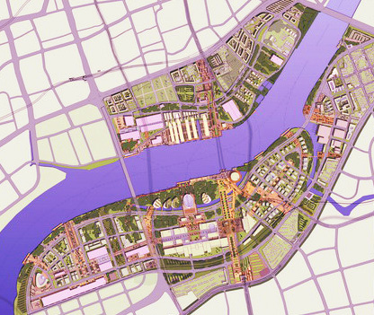
Hereunder we show the map of Shanghai Expo 2010. This is an area of 5.3 sq km situated on both banks of the Huangpu River, especially between Nanpu Bridge and Lupu Bridge. The map shows a clear rather of various areas of exhibition. Although the space occupied by the Shanghai Expo 2010 is very large, in reality the shape of buildings and pavilions is easy to understand. As explained on another page of our site, turn Expo 2010 is quite easy through multiple transport systems including the subway, ferry, buses, taxis. MAP OF SHANGHAI EXPO 2010
In this map you can see and understand the conformation of World Expo Shanghai 2010. To provide a better service for our visitors we believe to also make available a Map of Metro Shanghai and the Shanghai Map with hotels positioned. Many of our visitors have also found our Page with Pictures of the Shanghai Hotels, where you can choose a hotel in Shanghai through the photos.
|
Main Cities in China Travel and China Hotels


 Beijing Canton
Shanghai Hong
Kong Qingdao Hangzhou Beijing Canton
Shanghai Hong
Kong Qingdao Hangzhou |
Other Major Cities:
Changchun,
Chengdu,
Chongqing,
Dalian,
Dongguan,
Dunhuang,
Foshan,
Guangzhou,
Guilin,
Haikou,
Harbin,
Hainan,
Hangzhou,
Kunming,
Lhasa,
Macau,
Nanjing,
Qingdao,
Sanya,
Shenyang,
Suzhou
Shanghai,
Shenzhen,
Tianjin,
Weihai,
Wenzhou,
Xiamen,
Xi'an,
Yiwu
|
Major China Hotels:
Beijing Hotels,
Chengdu Hotels,
Chongqing Hotels,
Dalian Hotels,
Foshan Hotels,
GuangZhou Hotels,
Guilin Hotels,
Hangzhou Hotels,
Harbin Hotels,
HongKong Hotels,
Kunming Hotels,
Macau Hotels,
Nanjing Hotels,
Qingdao Hotels,
Sanya Hotels,
Shanghai Hotels,
Shenyang Hotels,
Suzhou Hotels,
Tianjin Hotels,
Urumqi Hotels,
Wenzhou Hotels,
Xiamen Hotels,
Xian Hotels |
| |

|
